Engraving
Maker & role
Chez Pillet Aîné, Publisher; Imprimeur-Libraire, Publisher; Victor Vincent Adam (b.1801, d.1866), Engraver; A. de Gestas, Artist
Production date
1825
See full details
Object detail
Title
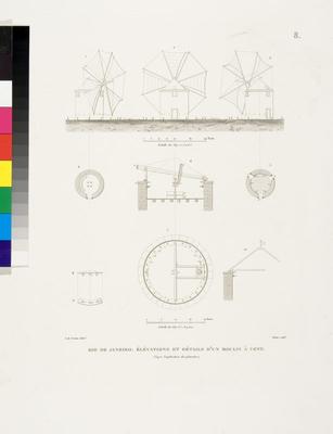
Elevation et details d'un Moulin a vent, a Rio de Janeiro
Production place
Collection
Measurements
0 - Whole, H: 49.5 x W: 33.5cm (H: 495 x W: 335mm)
Production notes
Entire atlas (MOS2005/32-1:118) finished by hand after Freycinet, J. Arago, A. Pellion and others, by Desaulx, E. Aubert, Chaselet and others.
Subject Place
Credit line
Gift, through the Australian Government’s Cultural Gifts Program, 2004
Caroline Simpson Collection, Museum of Sydney Collection, Museums of History New South Wales
Caroline Simpson Collection, Museum of Sydney Collection, Museums of History New South Wales
Caption
Elevation et details d'un Moulin a vent, a Rio de Janeiro, 1825
Description
Louis-Claude de Saulces de Freycinet (1779 – 1842), Voyage autour du Monde … Atlas Historique, Paris, 1825. It includes 112 engraved maps, plans, views and plates (comprising 12 maps or plans, one double-page, one folding, both of these with routes marked in colour by hand; 100 views, portraits and plates, 41 hand-coloured or printed in colour and finished by hand).Louis-Claude de Saulces de Freycinet was a significant French explorer who, from 1817-1820, commanded his own expedition in the corvettes Uranie and Physicienne to circumnavigate the globe and conduct research into meteorology and terrestrial magnetism. The Atlas Historique accompanied Freycinet’s official account of that voyage. The artwork from Freycinet’s circumnavigation on the Uranie also includes engravings of the places they visited on the voyage based on the original drawings and watercolours by artists Jacques Arago, Adrien Taunay and J. Alphonse Pellion.Freycinet’s circumnavigation took him and his crew to Tenerife, Rio de Janeiro, Cape Town, Mauritius, La Reunion, the West coast of Australia, Timor, the Caroline, Marianne and Sandwich Islands, Port Jackson and around Cape Horn. Shipwrecked off the Falkland Islands, they were rescued and taken to Rio before returning to France in 1820.The Atlas Historique comprises rare and important documents providing a narrative of the French cartographic examination of New South Wales. In particular it contains important maps of New South Wales, the County of Cumberland and the town plan of Sydney, views of Parramatta and Government House Parramatta as well as views of the Blue Mountains and the Indigenous people from this area.
This acquisition is part of the Caroline Simpson Collection, originally housed at Clyde Bank, an 1820s Georgian mansion in The Rocks. Clyde Bank was acquired by Caroline Simpson in 1992 and, following its conservation, opened to the public in 1996 as a showcase for her private collection of Australian colonial furniture, pictures, objets d’art and images of colonial places from around the world.Caroline Simpson OAM (1930-2003) supported many causes during her lifetime, particularly the conservation and appreciation of Australia’s colonial heritage. Her philanthropy was generous but mostly anonymous. MHNSW is very privileged to receive this remarkably generous gift from Caroline Simpson’s children.
This acquisition is part of the Caroline Simpson Collection, originally housed at Clyde Bank, an 1820s Georgian mansion in The Rocks. Clyde Bank was acquired by Caroline Simpson in 1992 and, following its conservation, opened to the public in 1996 as a showcase for her private collection of Australian colonial furniture, pictures, objets d’art and images of colonial places from around the world.Caroline Simpson OAM (1930-2003) supported many causes during her lifetime, particularly the conservation and appreciation of Australia’s colonial heritage. Her philanthropy was generous but mostly anonymous. MHNSW is very privileged to receive this remarkably generous gift from Caroline Simpson’s children.
Accession number
MOS2005/32-14


Public comments
Be the first to comment on this object record.