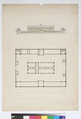
Architectural plan
Maker & role
Louis-Claude de Saulces de Freycinet (b.1779, d.1842), Artist; E. Olivier, Engraver
Production date
1819
1825?
See full details
Object detail
Title
Port Jackson. Plan et Elevation de la Caserne des Convicts, à Sydney
Production place
Collection
Measurements
1 - Pen and ink plan and elevation of Hyde Park Barracks., H: 40 x W: 28.5cm (H: 400 x W: 285mm); 2 - Proof engraving, H: 49 x W: 33.4cm (H: 490 x W: 334mm); 3 - Proof engraving, H: 49.5 x W: 36cm (H: 495 x W: 360mm)
Subject Place
Signature & marks
-1 Handwritten in pencil by Freycinet, bottom left corner in French " N.B. l'epaisseur veritable des murs est indiquee en bleu/partout our cette epaisseur doit etre changee/toutes les parties corrigees doivent avoir la meme epaisseur."
Signed and inscribed for the engraver "Dessine par.../E.Olivier/...d'apres un croquis de.../grave par".
On top left corner "No. 87".
Signed and inscribed for the engraver "Dessine par.../E.Olivier/...d'apres un croquis de.../grave par".
On top left corner "No. 87".
Credit line
Purchase, with assistance of Foundation for the Historic Houses Trust of New South Wales, 2002
Hyde Park Barracks Collection, Museums of History New South Wales
Hyde Park Barracks Collection, Museums of History New South Wales
Caption
Port Jackson. Plan et Elevation de la Caserne des Convicts, Ã Sydney (1825)
Description
This c1819 plan and elevation of Hyde Park Barracks by Louis-Claude de Saules de Freycinet is a rare artwork associated with French world expeditions in the early 19th century.
Port Jackson. Plan et Elevation de la Caserne des Convicts, à Sydney is a pen and ink drawing which shows the familiar Barracks central dormitory building and gatehouses, the solitary cells, superintendent's quarters and bakehouse of the northern range and the kitchen, and mess-rooms of the southern range which have long since been demolished. The accompanying elevation of the Barracks is in watercolour. It is likely that Emile Edmond Olivier worked up the plan and elevation later in France.
The plan and elevation is one of the earliest surviving records of the Barracks and one of the earliest architectural drawings made in Australia.
Louis de Freycinet served under Nicolas Baudin on his voyage of discovery from 1800 to 1804. As well as charting Australia's coastline, the French were interested in the progress of the British settlement at Port Jackson and the politically and economically advantageous location of settlements in or near the Pacific. Freycinet later commanded a scientific expedition around the world, sanctioned by Louis XVII in the Uranie from 1817 to 1820. It is from this voyage that the plans of the Barracks were made.
The Uranie anchored at Neutral Bay on 18 November 1819 before leaving on Christmas Day of the same year. Freycinet contacted Governor Macquarie to seek permission for his staff to visit the interior and to map the roads around the harbour from the entry to Sydney. Freycinet's botanists also made a number of scientific expeditions including some to the Blue Mountains and Bathurst Plains.
By June 1819 the Barracks had been completed by convict labour under the supervision of government architect and convicted forger, Francis Greenway. It is unclear if Freycinet appreciated Greenway's design or was just interested in documenting a convict barracks.
The drawing was made into an engraving and reproduced in Freycinet's Voyage autour du Monde…Atlas Historique. This was the voyage's official atlas of maps, plans, views and plates, published in Paris c1825. As well as providing rare historical evidence of the Barracks complex, fabric, rooms and spaces, the muted colours and intricate lines of the plan and elevation are aesthetically pleasing and show artistic skill and eye for detail.
Accession number
HPB2002/6-1:3


Public comments
Be the first to comment on this object record.